You are here

Back to top

Historic

Error message

  • Notice: Undefined index: main-menu in menu_block_view() (line 510 of /var/www/vhosts/portabidjan.ci/httpdocs/modules/menu/menu.module).
  • Notice: Undefined index: main-menu in menu_block_view() (line 510 of /var/www/vhosts/portabidjan.ci/httpdocs/modules/menu/menu.module).
THE MAJOR PLAYERS IN ABIDJAN PORT DEVELOPMENT
The birth of a modern port
Development Master Plans

THE MAJOR PLAYERS IN ABIDJAN PORT DEVELOPMENT

The extraordinary growth of the Port of Abidjan, which has allowed it to be one of the major pillars of the famous "Ivorian miracle", has been possible thanks to many historical actors whose enlightened vision has favored, at various levels, the planning different stages of its development.

It is first of all the visionary President Félix Houphouët BOIGNY, whose ideological and political choices made Côte d'Ivoire a landmark in the sub-region, thus laying the foundations for the development of the modern port. what is the Port of Abidjan.

Then, there are several generations of Ministers of technical and administrative supervision, Directors General and talented engineers who have implemented the policy defined by successive governments, thus contributing to the development of the Port of Abidjan.


Some are quoted below:


Marcel GOSSIO

Since November 15, 2000

Mamadou KONE

January 2000-November

Serge Allah ABOIDJE

November 1998-January 2000

Jean-Michel MOULOD

1981-November 1998

Ibo OKOUE

May 1979- 1981

Laurent ODAH

May 1967- 1979

Jean PAUTREL

1959-1967

Marcel ADAM

1952-1959

Jean MILLER

1950-1952

Lamine FADIGA

Minister of the Navy

Désiré BONI

Minister of Public Works and Transport

Alcide KACOU

Minister of Public Works of Urban Planning Transport of Post and Telecommunication Construction

THE BIRTH OF A GREAT MODERN PORT

 Ideally located in the heart of the Gulf of Guinea, almost equidistant from Cameroon and Senegal, Côte d'Ivoire has a coastline of about 500 kilometers. Its sandy and straight coast is <> by the bar, a wave breaking phenomenon forming at a distance of 80 to 100 meters and which, breaking on the shore, makes the ribs particularly difficult to access.

All along the coastline extends a vast network of lagoons separated from the sea by the "coastline" and to which flow the different rivers that water the country.


The fairgrounds and wharves

It was in the fifteenth century that the first trade between the Europeans and the natives of present-day Côte d'Ivoire began. First made by fairgrounds, these exchanges will continue later (from the 20th century), using wharfs that offered more security.

Thus, several wharfs will be built on the Ivorian coast during the first half of the 20th century:

  • the first wharf at Grand Bassam in 1901;
  • the second wharf still at Grand Bassam in 1923;
  • the 3rd wharf at Port-Bouet in 1931;
  • the 4th wharf at Sassandra in 1951.

It is through these wharfs that all the maritime exchanges of Côte d'Ivoire will take place until the opening of the Vridi canal and the commissioning of the Port of Abidjan. Some of these Wharfs, like Sassandra's, will remain in operation for several years even after the port opens.

Over the years, due to the continuous growth of trade between Europeans and natives, and the difficulty of handling heavy loads, the need to have a real port was already real before the realization of different wharfs. In addition, even though the wharfs facilitated the handling of the goods, they did not completely eliminate the risks due to the state of the sea.

By the end of the 19th century, research had begun to determine the best location of the future port.


Choosing the port location

Studies were conducted along the coast as early as 1892 under the direction of Treich-Laplene and Binger.

Several other studies were subsequently conducted including that of Marchand in 1896, and that of Captains Houdaille, Thomass and Crosson-Duplessis in 1898.

These different studies explored the regions of:

  • Grand Bassam;
  • The harbor of Sassandra;
  • Grand-Lahou

Finally, and in accordance with the conclusions of the Crosson-Duplessis study, Abidjan was chosen to be both the site of the future port and the bridgehead of the Abidjan-Niger railway.

Further studies will be carried out to determine the exact location of the future port and, in particular, the most appropriate location for piercing the coastline.

Later, the first attempts to break the shoreline that took place west of Port-Bouët (near Petit-Bassam) in 1906 and 1907 ended in failures, the open canals being immediately filled by sand currents.

As a result of these failures, several other projects were proposed by different engineers between 1909 and 1929, but none of them could satisfactorily solve the question of piercing the canal.

As a result of these failures, several other projects were proposed by different engineers between 1909 and 1929, but none of them could satisfactorily solve the question of piercing the canal.


Construction of the Port of Abidjan

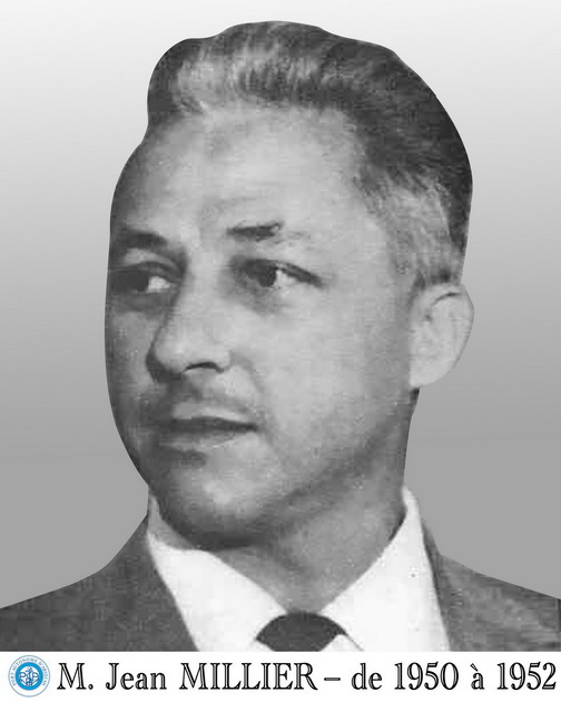
After the approval of Roger Pelnard-Considère's project, the works of the Vridi Canal were awarded to a consortium of companies in 1936. But the actual works did not begin until 1938. They continued under the successive authority of the Directors of Public Works Levy, Pelnard-Consider, Pilot, Pougnaud, Vernisse and Jean Millier. It was the latter who completed the work and later became the first director of the Port of Abidjan.

The work consisted of dredging the canal, constructing two jetties at sea to protect the entry pass against the sand currents, the execution of the rockfill shorelines, and the use of the rock-rubbed fascination mats for the protection of funds.

The digging of the canal was done at the same time sea side and lagoon side. This allowed the beginning of operation, from 1948, of the part sea side known as "Before port" to relieve the economy, then on the verge of asphyxiation because of the saturation of the wharfs of Grand-Bassam and Port- Bouet.

The digging of the canal was done at the same time sea side and lagoon side. This allowed the beginning of operation, from 1948, of the part sea side known as "Before port" to relieve the economy, then on the verge of asphyxiation because of the saturation of the wharfs of Grand-Bassam and Port- Bouet.

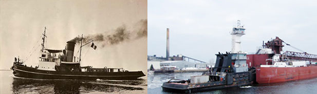
With the opening to navigation of the Vridi canal was born the Port of Abidjan. The first ship to use the Vridi Canal was "MARIE DOMINIQUE" and the first long-distance ship was "VOLTA". The Port of Abidjan was officially inaugurated on February 5, 1951 by Mr. François Mitterrand, then French Minister of Overseas Territories.

DIRECTIONAL DEVELOPMENT PLANS

 To respond to the increasing evolution of the volume and the nature of the traffic and to face the multiple and rapid mutations of the maritime transport of the last decades the Port of Abidjan conceived and rigorously executed, since its creation, two (2) master plans :

  • The first master plan (1951-1967);
  • The second master plan (1967-1980).


The first master plan (1951-1967)

The first master plan allowed for the following infrastructure and facilities:

  • North quays at the coast + 3.50 m and founded at 10 m; 775 m long, they have five (5) stores with a total area of ​​28,800 m2 divided into five (5) berths;
  • West quays at the coast + 3.50 m and founded at 10 m; 1,525m long, they have 10 berths and ten (10) 54,000sqm holdings;
  • The first part of the Fishing Port with a length of 400 m at the coast + 2.50 m of which 190 m with funds of - 5.00 and 210 m at - 7.00;
  • Fruit pier 350 m long at the coast + 2.50 m and at -7.00 m
  • Several specialized positions:
    • Hydrocarbon concessions on the east bank of the canal;
    • Log wood park;
    • Vessel receiving station for offshore oil tankers;
    • Carriage wharf 275 m to +2,50 m between the post 15 bis and Outillage du Port, with a shed of 3,200 m2;
    • Sheet metal pier 150 m at the coast + 3.50 m and funds at -7.00 m, located between the post 15 and the Outillage du Port.


Le deuxieme plan directeur (1967-1980)

The second master plan allowed the realization of:

  • The Vridi dike, 1,700 m long and 1,050 m wide;
  • The south quays
    • Post No. 16 to 21: total length 1,260 m, coastline + 3,50 m, bottom at - 11,50 m with five (5) storehouses covering 26,400 m2.
  • The container terminal: four (4) berths at the coast + 3.50 m with funds at - 12.00 m;
  • The second and third stages of the Fishing Port:
    • 425 m of steel sheet piling quay at + 2.50 m with bottoms at - 7.00 m;
    • 225 m of steel sheet piling quay at + 2.50 m with depths of - 7.00 m to - 11.50 m;
  • Chemical fertilizer wharf at the exit of the Vridi Canal, at the coast + 3.50 m and at - 10.00 m;
  • The construction of an industrial zone and an area of ​​naval industries;
  • The construction of a sand stop dike to the west of the entrance to the Vridi canal;
  • The removal of rocky spikes hindering navigation in the Vridi Canal.

Major works since 1980 and the third master plan

Following the completion of the first two master plans, a third master plan was prepared in 1985, including:

  • The rehabilitation and modernization of the existing harbor, which was already showing signs of saturation
  • Extension to new sites (Yopougon, Ile Boulay, West Coast Cord).


However, the implementation of this plan was thwarted by the economic crisis of the 1980s, which hit the country hard. However, some projects of modernization and rehabilitation of infrastructures on the one hand, and acquisition of advanced equipment on the other hand, have been realized.

These include, among others:

  • Paving of the medians at 125,000 m²;
  • Rehabilitation of railways in the bonded area of ​​3.815 m;
  • Realization of the linkage link with a 174 m bridge;
  • Construction of a new 4.5 ha deforested woodlot;
  • Construction of a new 150 m long fishing pier founded at -7.00 m on the former site of the lumberyard (wharf 15 bis);
  • Acquisition of two container cranes in 1986;
  • 150 m extension of the sand stop dike (1995-1996);
  • Complete rehabilitation of the first 2 container cranes (1998-1999);
  • Construction of a new building to house the General Directorate of the Autonomous Port of Abidjan;
  • Acquisition of a third container crane in 1999;
  • Rehabilitation and modernization of the fruit terminal (end of work in 2003).


In 1998, the Port Authority decided to update the master plan drawn up in 1985.

The beginning of the implementation of this plan was marked by the project of extension of the Port to Yopougon in the form of BOT whose convention was signed in 2000 with the Anglo-Dutch consortium LODECO.

Unfortunately, given the socio-political crisis that Côte d'Ivoire has been experiencing since 1999, this project could not be realized.

Port Autonome d'Abidjan

Vue d'un conteneur

Société d'Etat au capital de
16 000 000 000 FCFA
Régistre de commerce N°182461